


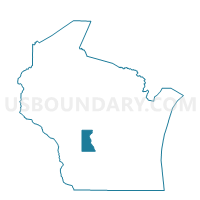
ORANGE - T 1 Voting District, Juneau County, Wisconsin
About
Outline

Summary
| Unique Area Identifier | 694264 |
| Name | ORANGE - T 1 Voting District |
| County | Juneau County |
| State | Wisconsin |
| Area (square miles) | 35.13 |
| Land Area (square miles) | 35.11 |
| Water Area (square miles) | 0.01 |
| % of Land Area | 99.96 |
| % of Water Area | 0.04 |
| Latitude of the Internal Point | 43.93835240 |
| Longtitude of the Internal Point | -90.24390860 |
Maps


Graphs
Select a template below for downloading or customizing gragh for ORANGE - T 1 Voting District, Juneau County, Wisconsin


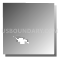


Neighbors
Neighoring Voting District (by Name) Neighboring Voting District on the Map
- BYRON - T 2 Voting District, Monroe County, WI
- Camp Douglas - V 1 Voting District, Juneau County, WI
- CLEARFIELD - T 2 Voting District, Juneau County, WI
- CLIFTON - T 1 Voting District, Monroe County, WI
- CUTLER - T 1 Voting District, Juneau County, WI
- FOUNTAIN - T 1 Voting District, Juneau County, WI
- LISBON - T 1 Voting District, Juneau County, WI
- NECEDAH - T 1 Voting District, Juneau County, WI
- OAKDALE - T 1 Voting District, Monroe County, WI
Top 10 Neighboring County Subdivision (by Population) Neighboring County Subdivision on the Map
- Necedah town, Juneau County, WI (2,327)
- Byron town, Monroe County, WI (1,342)
- Lisbon town, Juneau County, WI (912)
- Oakdale town, Monroe County, WI (772)
- Clearfield town, Juneau County, WI (728)
- Clifton town, Monroe County, WI (690)
- Camp Douglas village, Juneau County, WI (601)
- Orange town, Juneau County, WI (570)
- Fountain town, Juneau County, WI (555)
- Cutler town, Juneau County, WI (326)
Top 10 Neighboring Place (by Population) Neighboring Place on the Map
Top 10 Neighboring Unified School District (by Population) Neighboring Unified School District on the Map
- Tomah Area School District, WI (20,020)
- New Lisbon School District, WI (5,206)
- Necedah Area School District, WI (4,612)
Top 10 Neighboring State Legislative District Lower Chamber (by Population) Neighboring State Legislative District Lower Chamber on the Map
Top 10 Neighboring State Legislative District Upper Chamber (by Population) Neighboring State Legislative District Upper Chamber on the Map
Top 10 Neighboring 111th Congressional District (by Population) Neighboring 111th Congressional District on the Map
Top 10 Neighboring Census Tract (by Population) Neighboring Census Tract on the Map
- Census Tract 1004, Juneau County, WI (5,169)
- Census Tract 9507, Monroe County, WI (4,511)
- Census Tract 1002, Juneau County, WI (3,669)
- Census Tract 1001, Juneau County, WI (2,874)